
Class 8 Social Science Part II Chapter 1: World Geography: Some Glimpses Solutions
These Class 8 Social Science Part 2 Chapter 1 solutions explain World Geography: Some Glimpses. Explore the oceans, continents and landforms, then connect them with climate, biodiversity, livelihoods and conservation.
Use the chapter title and Part II numbering to match your school textbook. These are original ClearStudy explanations. Open-ended tasks have sample answers; your observations and local examples may differ. Question prompts are shortened for reference; read the complete tasks in your textbook.
- Chapter overview and revision
- The Big Questions
- In-text questions and activities
- Questions and activities: exercise solutions
- Frequently asked questions
World Geography: Some Glimpses: chapter overview
Maps help us locate places, but every flat world map distorts some combination of area, shape, distance or direction. Oceans store and redistribute heat; mountains supply water; plains support farming and settlements. Deserts, forests and grasslands each support distinctive adaptations and ways of life.
| Continent | Examples | Connection with life |
|---|---|---|
| Asia | Tibetan Plateau, Gobi, steppes, Urals | River sources, grazing, minerals and climate |
| Europe | European Plain, Alps | Farming, transport, mountain water and tourism |
| Africa | Sahara, savannah, Nile | Desert adaptations, seasonal wildlife and irrigation |
| South America | Andes, Amazon, Atacama | Freshwater, biodiversity, carbon storage and arid landscapes |
| North America | Colorado Plateau, Rockies, Appalachians, Great Lakes | Canyons, forests, minerals, shipping and freshwater |
| Australia | Great Australian Desert, Great Barrier Reef | Arid-land adaptation and marine biodiversity |
| Antarctica | Ice-covered polar desert | Freshwater locked in ice and global climate connections |
The Big Questions
Big Question 1: What are the unique physical features of the continents?
Each continent combines several landforms. Asia has the high Tibetan Plateau and the Gobi; Europe has broad plains and the Alps; Africa has the Sahara, savannah and Nile; South America has the Andes, Amazon basin and Atacama; North America has the Rockies, Colorado Plateau and Great Lakes; Australia has extensive deserts and offshore reefs. Antarctica is a very cold, ice-covered continent. No continent has only one kind of landscape.
Big Question 2: Why do we need to understand world geography?
It explains how land, water, climate and ecosystems shape settlements, food production, trade and culture. It also shows connections across regions: ocean currents move heat, rivers cross borders and environmental damage can affect distant places. This knowledge supports informed conservation and planning.
Big Question 3: How do human actions trigger environmental issues?
Clearing forests destroys habitats and releases stored carbon. Overgrazing and poor land management can degrade soils. Industrial waste, agricultural runoff and discarded products pollute water and land. Greenhouse-gas emissions warm the atmosphere and oceans, contributing to coral bleaching and changing ice cover. The effects vary by place and interact with natural processes.
In-text questions and activities
Follow the textbook page references below. Suggested responses help you reason through discussion, observation and project tasks.
p. 2 · Let’s Explore: Interpret the colours on the physical image and map.
Blue indicates water; green commonly indicates low plains; yellow or brown indicates higher land such as plateaus; darker brown indicates mountains; pale yellow may indicate deserts; white indicates ice or snow. Always consult the map legend: a satellite image records surface appearance, while a physical map may deliberately colour elevation. The same colour does not mean exactly the same thing on every map.
p. 3 · Map comparison: Why does Greenland appear larger on the Mercator map?
Mercator stretches area increasingly towards the poles. Greenland is at high latitude, so it appears disproportionately large. India is actually larger in area. A globe or an equal-area projection is better for comparing areas; Robinson is a compromise projection and is not perfectly equal-area.
p. 4 · Think About It: What could happen if pollution harmed oxygen-producing plankton?
Less photosynthesis would weaken marine food webs and affect fish and other animals that depend on them. It would also reduce oxygen production locally and could disturb carbon cycling. The effects would depend on the scale and duration; atmospheric oxygen would not suddenly disappear. Protecting marine ecosystems matters for biodiversity, fisheries and climate.
p. 11 · Let’s Explore: Identify the physical features of Asia in Fig. 1.11.
Find the Tibetan Plateau south of the Gobi, the Gobi Desert in Mongolia and northern China, the long belt of Eurasian steppes, the Siberian taiga to the north, and the Ural Mountains near the conventional Europe–Asia boundary. Use the legend and compass rather than guessing from colour alone.
p. 12 · Figure observation: Compare the Tibetan Plateau pictures from 1987 and 2021.
The later lake image appears to show larger or joined areas of water and changes around their margins. The chapter relates expanding lakes to warming and meltwater. State only what the pair shows: colour differences can also come from season, lighting or image processing, so two images alone do not measure the rate or prove a single cause.
p. 15 · Let’s Explore: Describe the Himalayas as water towers, climate influences, habitats and boundaries.
Snow, glaciers and mountain rainfall feed rivers used downstream for drinking water, farming and power. The range alters wind and rainfall patterns, including monsoon precipitation, and limits some cold northern air. Changes in altitude create varied habitats. The mountains also form important natural barriers and sections of international boundaries, although the whole range is not a single political boundary.
p. 18 · Let’s Explore: List countries crossed by the European Plain.
A reasonable atlas-based list includes parts of France, Belgium, the Netherlands, Germany, Poland, Belarus, Ukraine and European Russia. Depending on how the plain is delimited, other adjoining lowland areas may be included. Trace the shaded physical region first, then compare it with the political map; do not assume the whole of each country is flat.
p. 22 · Let’s Explore: Locate the Nile’s sources, direction and countries.
The White Nile system is associated with the Lake Victoria region and headwaters farther south; the Blue Nile begins at Lake Tana in Ethiopia. They meet at Khartoum in Sudan. The river flows mainly north through Sudan and Egypt to the Mediterranean. The White Nile route also passes through Uganda and South Sudan. Distinguish the river’s course from its much larger drainage basin.
p. 24 · Let’s Explore: Explain the ‘lungs’ metaphor and discuss Amazon deforestation.
Leaves absorb carbon dioxide during photosynthesis and release oxygen, suggesting the comparison with lungs. However, forest respiration and decomposition consume much of that oxygen; the Amazon does not supply a fixed large share of the oxygen people breathe. Short-term clearing may provide farmland or timber income, but it destroys habitats and affects communities. Longer-term losses include carbon storage, rainfall recycling and soil protection. Protect forests and Indigenous land rights, use already-cleared land more efficiently and support sustainable livelihoods.
p. 25 · Environmental reflection: What does the Atacama clothing-waste example teach us?
Cheap clothing can carry environmental costs far from its users. Discarded textiles occupy land, shed fibres and may release pollutants when burnt. Buy fewer durable garments, repair and reuse them, choose responsible collection and recycling, and support producers and authorities that manage waste. Reducing waste is more useful than simply moving it elsewhere.
p. 29 · Figure observation: What do the colours suggest about Australia’s landforms?
Much of the interior is arid or semi-arid. The map also indicates higher eastern land, coastal lowlands and surrounding oceans, with the Great Barrier Reef off the northeast coast. Colour is a guide to elevation or surface type according to the legend; it cannot by itself tell us the exact rainfall or population.
pp. 33–34 · Looking back and forward: How do the Odisha movements connect the two historical chapters?
The bridge revisits resistance to colonial land-revenue demands and interference in local authority. In the Paika uprising of 1817, Buxi Jagabandhu helped unite several affected groups. Surendra Sai’s resistance in Sambalpur also drew on regional support and knowledge of forested terrain. These examples show that opposition to British rule had many regional roots before the wider national movement discussed in Chapter 2.
Questions and activities: exercise solutions
Answers follow the printed exercise order (pp. 31–32).
Question 1: Why do all map projections have some distortion?
A map projection transfers the curved surface of the Earth onto a flat plane. Like an orange peel, that curved surface cannot be flattened without stretching, cutting or compressing it. Consequently, every world projection distorts at least one property: area, shape, distance or direction. Cartographers choose the projection that best suits the map’s purpose.
Question 2: What makes the Tibetan Plateau unique?
It is the world’s highest and largest plateau, with an average elevation above 4,500 metres. It formed through tectonic collision and uplift, lies north of the Himalayas and influences Asian climate. Its snow and glaciers help supply major river systems including the Indus, Brahmaputra and Yangtze, which is why the wider high-mountain region is called the ‘Third Pole’.
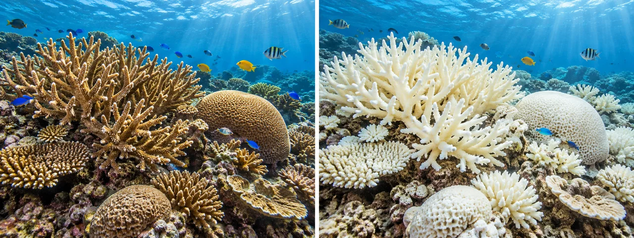
Question 3: Why are coral reefs called the ‘rainforests of the sea’?
Reefs support exceptional biodiversity in a relatively small area. Corals create a complex habitat offering shelter, feeding grounds and breeding spaces for fish and many other marine organisms. Their ecological richness explains the comparison with rainforests; it does not mean corals are plants.
Question 4: How do oceans regulate Earth’s climate?
Water absorbs and stores large amounts of heat and releases it gradually, moderating coastal temperatures. Ocean currents move warm and cold water between regions. Evaporation supplies moisture for clouds and rainfall, while the ocean also absorbs carbon dioxide. These processes connect ocean conditions with climate on land.
Question 5: What is the main reason the Great Barrier Reef faces threats?
Human-driven climate change raises sea temperatures, causing repeated heat stress and coral bleaching. Corals lose the microscopic algae that help feed them and give them colour; prolonged stress can kill them. Pollution, sediment runoff and other pressures worsen damage. Ocean acidification is another climate-related threat, but bleaching and acidification are different processes. A bleached coral is not necessarily already dead.
Question 6: Why is the Amazon called the ‘Lungs of the Earth’?
The expression refers to photosynthesis by its vast vegetation, which absorbs carbon dioxide and releases oxygen. More precisely, the forest is vital for biodiversity, carbon storage and recycling moisture into rainfall. Respiration and decomposition use much of the oxygen produced, so the phrase is a metaphor rather than a literal estimate of the world’s oxygen supply.
Question 7: Choose two geographical features and explain their local and global effects.
Mountains — the Himalayas: altitude creates varied habitats, while snow, glaciers and rainfall supply downstream rivers. Farming, settlements and hydropower depend on that water. Mountain climate and water changes affect people across several countries.
Rainforest — the Amazon: warm, wet conditions support dense vegetation and many species. Communities use forest and river resources. The forest stores carbon and recycles moisture, so large-scale loss can affect climate and biodiversity beyond the basin.
Question 8: Discuss ocean influences on climate and trade, using the Indian and Pacific Oceans.
The Indian Ocean provides moisture and heat that influence South Asian monsoons. Its shipping routes connect India with West Asia, Africa and Southeast Asia; access through the Suez Canal shortens many routes to Europe. The Pacific’s ocean–atmosphere patterns, including El Niño and La Niña, affect rainfall and temperatures in several regions. Pacific sea routes connect Asian ports with the Americas and Oceania. Thus oceans influence both environmental conditions and the movement of goods.
Question 9: Choose an environmental issue and explain causes, impacts and solutions.
Issue: coral bleaching. Unusually warm water stresses corals, leading them to lose their symbiotic algae. Pollution and other stresses can compound the problem. Repeated or prolonged bleaching damages reef habitats and can affect fishing, tourism and coastal protection. Solutions include reducing greenhouse-gas emissions, improving wastewater and runoff management, protecting reef habitats and avoiding destructive fishing. Reef protection helps, but it does not substitute for addressing warming.
Question 10: Which major landscape would you advise a government to protect, and why?
I would choose the Indian Himalayan landscape. It supplies water, supports biodiversity and provides livelihoods. I would recommend protecting forests and catchments, preventing dumping in rivers, planning construction with slope and drainage risks in mind, and involving local communities. Carefully managed tourism and monitoring of glaciers and hazards would help conserve the landscape while supporting people who live there.
Question 11: Pitch a road trip across two continents and trace a route on a blank map.
Choice: Europe and Asia. A classroom route could run Lisbon → Madrid → Paris → Berlin → Warsaw → Moscow → the Ural region → Novosibirsk → Irkutsk → Ulaanbaatar → Beijing. It would compare European plains, the Europe–Asia boundary, Siberian environments and Mongolian grassland or desert landscapes.
On a blank world map, mark the cities, label the two continents and draw the broad route. Add a legend and explain the physical features you want to study. This is a geographical proposal, not a checked travel itinerary; actual roads, border permissions and current conditions would require separate research. Different routes are acceptable if the locations and reasoning are accurate.
Frequently asked questions
Does Part II Chapter 1 continue Part I’s chapter numbering?
No. In the supplied June 2026 edition, Part II begins again with Chapter 1, World Geography: Some Glimpses. Check both the book part and the chapter title.
How many end questions are in this chapter?
The Questions and activities section has 11 numbered tasks on pages 31–32. Several are discussions or projects with more than one acceptable response.
Are bleached corals always dead?
No. Bleached corals have lost their symbiotic algae and are stressed. They can recover if conditions improve, but prolonged stress can cause death.
Textbook reference: NCERT, Exploring Society: India and Beyond, Grade 8, Part 2, first edition June 2026, Chapter 1, “World Geography: Some Glimpses”. Compare with your school’s copy; official NCERT textbook portal. Scientific clarification: NOAA on coral bleaching. ClearStudy is an independent study resource.