
NCERT Solutions for Class 7 Social Science (Exploring Society) Chapter 3: Climates of India
These Class 7 Social Science Exploring Society Chapter 3 solutions cover Climates of India from Exploring Society: India and Beyond (Part 1), the NCF-2023 textbook (2026–27 reprint). The chapter belongs to the theme India and the World: Land and the People and explains the difference between weather, seasons and climate, the main types of climate found across India, the five factors that determine climate, the working of the monsoons, how climate shapes our culture and economy, climate-related disasters, and the meaning and consequences of climate change. Below you get step-by-step answers to all Questions and activities, clear notes on key terms, extra practice, MCQs, Assertion–Reason and FAQs.
Class 7 Social Science Exploring Society Chapter 3 – Overview
Chapter 3, Climates of India, first clears up the common confusion between weather (what we experience hour to hour or day to day) and climate (the long-term pattern of weather over several decades). It then surveys the many types of climate found in India — alpine, temperate, subtropical, arid, tropical wet, semi-arid and tropical — and explains the five factors that create them: latitude, altitude, proximity to the sea, winds and topography. The chapter describes the monsoons (the seasonal winds and rains that are central to Indian life), explaining the summer (southwest) and winter (northeast) monsoons. It shows how climate shapes our festivals, culture and economy (the danger of ‘monsoon failure’), and examines climate-related disasters — cyclones, floods, landslides and forest fires. Finally it introduces climate change, the greenhouse effect, global warming and the need for mitigation, resilience and sustainable living.
Key Concepts & Terms
Weather: what we experience from hour to hour or day to day — rain, sunshine, wind, heat or cold. The weather keeps changing.
Climate: the pattern of weather an area or region experiences over a long period of time — at least several decades. It varies from region to region.
Seasons (ṛitus): recurring periods (spring, summer, monsoon, autumn, winter) linked to Earth’s tilted axis as it revolves around the Sun; regional rainy seasons also depend on atmospheric circulation. Traditionally India recognises six ṛitus — vasanta, grīṣhma, varṣhā, śharad, hemanta and śhiśhir.
Types of climate in India: alpine (Himalayas — cold snowy winters, cool summers), temperate (lower Himalayas, hill stations), subtropical (northern plains — very hot summers, cold winters), arid (Thar Desert — very hot days, cool nights, little rain), tropical wet (western coastal strip — heavy monsoon rain), semi-arid (Deccan Plateau), and tropical (eastern India and the southern peninsula).
Factors determining climate: (a) latitude — places near the Equator are warmer, those near the poles colder; (b) altitude — temperature falls as height increases; (c) proximity to the sea — the sea moderates temperature; (d) winds — carry warm/cool air and moisture; (e) topography — mountains and the shape of the land influence climate.
Microclimate: a climate localised in a small area that differs from the surrounding region, e.g. enclosed valleys, forests, and ‘urban heat islands’.
Monsoon: from the Arabic mausim (‘season’); seasonal winds (and the rains they bring) over the Indian Ocean and surrounding regions. The summer/southwest monsoon provides the main rainy season from June to September; early June to around mid-July describes its advance across the country, not its full duration; the winter/northeast monsoon brings dry winds and some rain to east and south India.
Climate-related disasters: cyclones (rotating low-pressure storms; strong, organised cyclones may have an eye), floods (water overflowing onto dry land), landslides (sudden collapse of rock and soil), and forest fires (uncontrolled fires across vegetation).
Climate change: significant, long-term shifts in temperature, precipitation and weather events. Since the 19th century it has been largely driven by human activities, especially the burning of fossil fuels, which release greenhouse gases and intensify the greenhouse effect, causing global warming.
Other key terms: Topography (the totality of an area’s physical surface features), Resilience (the capacity to withstand or recover from difficulties), Mitigation (steps to slow global warming and reduce the causes of climate change), Sustainable (something that can be maintained over a long period of time).
“Questions and activities” — Full Solutions
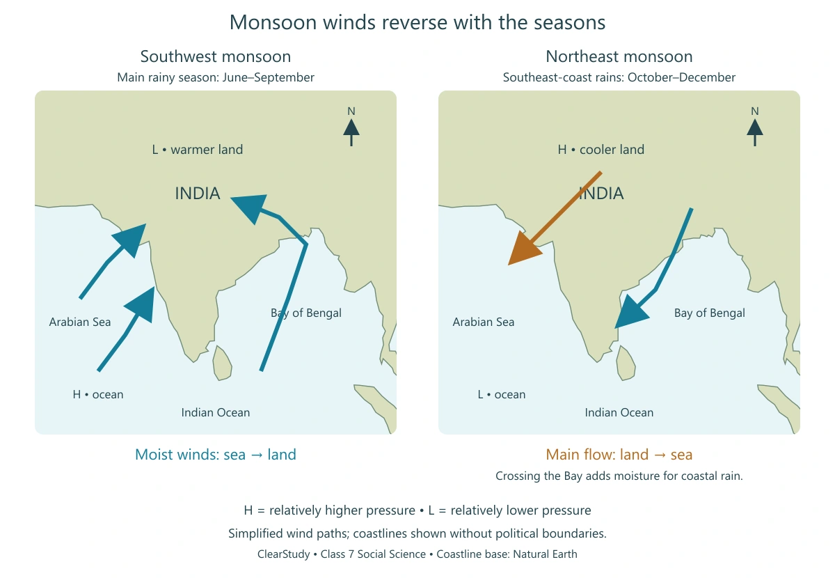
The seven numbered tasks follow NCERT, pp. 65–66. ClearStudy provides model answers, not an official answer key. Adapt creative activities to your location and experience. The monsoon illustration below supports the map task.
1. Match the climatic factors with their effects:
| Column A (Climatic factor) | Column B (Effect) |
|---|---|
| (1) Latitude | (b) Creates different climates in the north and south |
| (2) Altitude | (c) Keeps higher places cooler |
| (3) Proximity to the ocean | (d) Moderates the temperature |
| (4) Monsoon winds | (a) Brings wet air to India during summer |
2. Answer the following questions:
a) What is the difference between weather and climate?
b) Why do places near the ocean have milder temperatures than places far away from it?
c) What role do monsoon winds play in affecting India’s climate?
d) Why is Chennai warm or hot throughout the year, while Leh is cold?
3. Look at a map of India given at the end of this book. Identify the climate for these cities — Leh, Chennai, Delhi, Panaji and Jaipur.
Is the place near the sea, in the mountains, or in the desert? How do these factors affect the climate there?
| City | Location | Climate & reason |
|---|---|---|
| Leh | In the high mountains (Himalayan region) | High-altitude cold desert climate — long cold winters, low precipitation and a short summer. Altitude and the Himalayan rain shadow are important. |
| Chennai | Near the sea (eastern coast) | Tropical climate — low latitude and nearness to the sea keep it warm/hot and humid through the year. |
| Delhi | In the northern plains, far inland | Subtropical climate — being inland gives very hot summers and cold winters (a large temperature range). |
| Panaji | Near the sea (western coast) | Tropical wet climate — the sea moderates temperature and it receives heavy monsoon rainfall. |
| Jaipur | Near/at the edge of the Thar Desert | Arid/semi-arid climate — very hot days, cooler nights and little rainfall. |
4. Draw the monsoon cycle in summers and winters on a map of India.
Label where the winds blow in summer and winter; Show the direction of winds during the monsoon
5. Make a colourful poster showing festivals in India linked to farming and weather (e.g., Baisakhi, Onam). Add pictures or drawings of these festivals.
- Baisakhi, Punjab: draw ripe wheat and harvesting; explain the spring harvest connection.
- Onam, Kerala: draw a flower arrangement (pookalam) and a harvest scene; note the festival’s connection with prosperity and the harvest season.
- Pongal, Tamil Nadu: draw a decorated pot of newly harvested rice with sugarcane; label it a January harvest thanksgiving.
- Bihu, Assam: distinguish Bohag/Rongali Bihu (spring and the new agricultural cycle) from Magh/Bhogali Bihu (post-harvest celebration).
6. Imagine you are a farmer in India. Write a short diary entry about how you would prepare for the rainy season.
7. Identify a natural disaster (e.g., cyclone, flood, landslide, or forest fire) and write a short essay that includes the causes and impacts. Suggest actions that individuals, communities and the government can take to reduce the impact.
Extra Practice Questions
These questions and MCQs are ClearStudy practice, separate from the NCERT exercise.
Short Answer Type Questions
Q1. What is a microclimate? Give one example.
Q2. Why does temperature decrease as altitude increases?
Q3. From which word does ‘monsoon’ come, and what does it mean?
Q4. What is the ‘eye of the cyclone’?
Q5. What is meant by ‘monsoon failure’ and how does it affect people?
Long Answer Type Questions
Q1. Describe the main types of climate found in India.
Q2. Explain how the summer and winter monsoons are formed.
Q3. What is climate change? Explain its causes and how it can be tackled.
MCQs & Assertion–Reason
1. Climate is best described as:
(a) the weather of a single day (b) the pattern of weather over several decades (c) the season at present (d) the daily temperature
2. The Himalayan mountains in the north of India have which type of climate?
(a) Arid (b) Tropical wet (c) Alpine (d) Semi-arid
3. Which factor explains why hill stations are cooler than the plains below?
(a) Latitude (b) Altitude (c) Proximity to the sea (d) Winds
4. The word ‘monsoon’ comes from the Arabic word mausim, which means:
(a) rain (b) wind (c) season (d) ocean
5. The summer monsoon in India is also called the:
(a) northeast monsoon (b) southwest monsoon (c) western disturbance (d) trade wind
6. Which place receives the highest average annual rainfall in the world (about 11,000 mm)?
(a) Cherrapunji (b) Mawsynram (c) Mumbai (d) Munnar
7. The calm, cloudless centre of a cyclone is called the:
(a) depression (b) low-pressure belt (c) eye of the cyclone (d) cyclonic circulation
8. Coastal areas such as Mumbai have milder temperatures than inland places like Nagpur because:
(a) they are at a higher altitude (b) the sea moderates the temperature (c) they are nearer the Equator (d) they receive no winds
9. Since the 19th century, climate change has been driven mainly by:
(a) natural processes alone (b) human activities such as burning fossil fuels (c) the rotation of the Earth (d) ocean currents only
10. Which force is specially trained to respond to natural and human-made disasters in India?
(a) IMD (b) ISA (c) NDRF (d) CPCB
For each Assertion–Reason question, choose: (A) Both true and the Reason correctly explains the Assertion; (B) Both true but the Reason is not the correct explanation; (C) Assertion true, Reason false; (D) Assertion false, Reason true.
A-R 1. Assertion: Places near the Equator are warmer than places near the poles.
Reason: Near the Equator the Sun’s rays are nearly perpendicular and their energy is concentrated on a smaller area.
A-R 2. Assertion: Coastal regions have a more extreme temperature range than inland regions.
Reason: The sea acts as a moderator, warming the air in winter and cooling it in summer.
A-R 3. Assertion: The summer monsoon winds blow from the ocean towards the land.
Reason: In summer the land heats up and forms a low-pressure system, drawing winds from the high-pressure ocean.
A-R 4. Assertion: Urban heat islands are warmer than the surrounding region.
Reason: Cities with many concrete buildings and little vegetation trap heat.
A-R 5. Assertion: Weather and climate mean exactly the same thing.
Reason: Climate is the long-term pattern of weather over several decades, while weather is what we experience day to day.
In-text activities: explain the connection
Ooty and Coimbatore (p. 51): they have similar latitudes, so altitude explains much of the difference: high Ooty is cooler than lower Coimbatore. Use the textbook’s temperature ranges as examples, not today’s forecast.
Seasons and local trees: record dates, local names, leaf changes, flowering and rainfall in your area. Some trees shed leaves in a dry season rather than before winter; use observations rather than assuming one pattern for all India.
Western Ghats: moisture-bearing winds rise on the western slopes, cool and give rain. The descending air to the east is generally drier, creating a rain-shadow effect.
Disaster comparison: separate the trigger (heavy rain, strong winds, dry conditions) from factors that increase damage (blocked drains, unsafe construction, vegetation loss, people living in exposed locations). Preparedness, warnings and suitable land use can reduce losses even when the natural event cannot be prevented.
Mitigation and adaptation: renewable energy and efficiency reduce emissions; flood preparedness and heat-resilient housing help people adapt to impacts.
Exam Tips & Common Mistakes
How to write a clear answer
Memorise the clear difference between weather (short-term) and climate (long-term, over decades) — use a short example to show the difference. Learn the five factors that determine climate (latitude, altitude, proximity to the sea, winds, topography) and be ready to give an Indian example for each. For monsoon questions, always explain it through pressure: land heats faster than the ocean, so summer winds blow sea→land (rain) and winter winds blow land→sea (dry). Use the textbook’s own examples — Mumbai vs Nagpur, Chennai vs Leh, Ooty vs Coimbatore, Mawsynram, the Western Ghats, Cyclone Fani and the 2013 Uttarakhand floods — to show you have studied the chapter.
Common mistakes to avoid
- Using “weather” and “climate” as if they mean the same thing — climate is the long-term pattern.
- Saying the summer monsoon blows from land to sea — it is the other way round (sea to land).
- Confusing the summer/southwest monsoon (heavy rain) with the winter/northeast monsoon (mainly dry).
- Mixing up the types of climate — alpine (Himalayas), arid (Thar Desert), tropical wet (west coast).
- Forgetting that altitude, not just latitude, makes places like Leh and hill stations cold.
- Leaving map, poster and diary activities blank — complete them using the instructions and your teacher’s marking criteria.
Frequently Asked Questions
What is Chapter 3 of Class 7 Social Science Exploring Society about?
Chapter 3, Climates of India, explains the difference between weather, seasons and climate, the main types of climate in India, the five factors that determine climate (latitude, altitude, proximity to the sea, winds and topography), how the summer and winter monsoons work, how climate shapes culture and the economy, climate-related disasters, and the meaning and consequences of climate change.
What are the five factors that determine the climate of a region?
The five factors are latitude (distance from the Equator), altitude (height above sea level), proximity to the sea, winds, and topography (the physical surface features of the land). Together these factors decide the temperature, rainfall and wind patterns of a region.
What is the exercise heading for Chapter 3 of Exploring Society?
The end-of-chapter exercise in Exploring Society: India and Beyond Chapter 3 is headed Questions and activities and contains 7 numbered questions, all answered step by step on this page.
Reviewed 10 October 2026 against NCERT Exploring Society: India and Beyond, Grade 7 Part 1, Chapter 3, pp. 45–66 (2026–27 reprint). Seasonal timing checked against IMD’s southwest and northeast monsoon reporting.